May, 2016, addition: Burn,
Alberta, Burn: You Deserve it.
1999+ Western Canada and US Drought:
The Evolving Sahara of North America
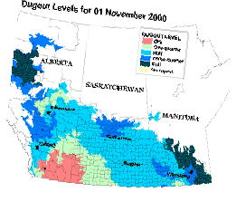
The below maps are from two separate sources but they show the
approximate overlapped drought areas of both western Canadian and western
U.S. which begin in the oil fields of Canada (Alberta and Saskatchewan. ).
The jet stream map at the bottom of this page shows how prevailing wind patterns
(the jetstream/Alberta Clipper) travel over and from Canadian and Alaskan
oil fields before dipping into the U.S. In addition, the volcanic plume of
the Mt.
St. Helen eruption shows shows how the jet stream bends plumes of ash
and gas--the Alberta Clipper. Given the intention to expand oil
production by the Canadians and Bushidians and given the prevailing wind
pattern from Western Canada and Alaska oil fiields (see
below wind map), the drought will only get
worst. The landscape scars from drought
enabled fires will become less noticeable as they become the norm.
 |
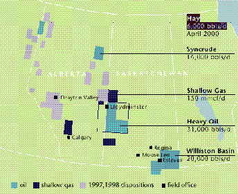
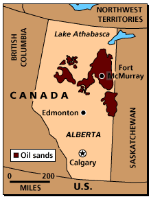
Western Canadian oil fields in Alberta and Saskatchewan from CandianOxy annual
report 1998. |
Description of Drought: See above Maps
-
Visit any of the Western states websites for accounts of droughts, dry rivers,
and fires.
-
The fires have left scars that are not only
unsightly but costly:
Billions of
dollars. The latter cost shows why oil is
timistically
negative.
-
The fires are deadly: Smoky Brush Fires Cause 18-Car Pileup (May 29, 2001)
-
Like all droughts since Biblical times, the
plague of bugs is upon the
land.
Upwind Oil Field Development
-
Canada (Alberta's capital celebrates its oil in its sport teams: Oilers and
Drillers.). Prudhoe Bay contributes when the winds are common.
-
Flaring is quite common in Canada--Combustion
Conumbrum.
-
"In Alberta, about 4,400 flares are flickering round the clock, burning natural
gas volumes produced from oil wells. Another 600 flares burn at gas plants
and scores of other mostly short-term flares are blazing away on any given
day."
-
"In its June 1998 report on flaring, the Clean Air Strategic Alliance said
about half the solution gas that is currently flared could potentially be
used to generate electricity. (Last year [1998], flares disposed of 1.451
billion metric tonnes -- 51.23 bcf -- of solution gas in Alberta, according
to Alberta Energy and Utility Board figures.)"
-
"The future of flaring in Western Canada is thick with uncertainty. Will
public pressure lead to an outright ban or will more sophisticated flaring
systems improve a blackened image?"
(The above figures are for Alberta alone. They do not include Saskatchewan
which the above graphic for Canadian drought shows to be as big as Alberta.)
-
CanadianOxy vents or flares enough natural gas to run a 50megawatt generator
(1998 annual report).
-
Alberta and Saskatchewan are developing large electricity-generating plants
to burn natural gas for exporting electricity to the U.S. The increased CO2
will result in de facto
flaring that will
inflationarily cheapen the downwind populace.
-
The nature of much of Canadian oil production necessitates extra CO2 generation
to produce a barrel of oil. The "Tar Sand" deposits of Alberta describes
how billions of gallons of oil are locked up in sands. To retrieve the
oil from the sand, the sand is heated up which generates constant, vast plumes
of CO2. Canadians and Americans face the choice: oil or butter?
-
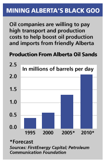
"Increasingly, those imports [instead of the MidEast] are coming from places
such as northern Alberta. Producers such as Conoco Inc. and Exxon Mobil Corp.
have invested $4 billion there since 1996 in the oil consortium Syncrude
.... The investments over 11 years are expected to double production by 2007,
to 500,000 barrels a day."
020315
Terminating Factor:
-
As the natural gas of Western Canada generates electricity for California,
downwind MT,WA,OR,UT & CO pay the price in drought conditions.
Prevailing Wind Patterns:
-
The below map shows an example of the jet stream coming out of Western Canada.
This pattern is the most frequent pattern so much so that it is called the
"Alberta Clipper." Note the upper
contribution coming from Alaska's Prudhoe Bay oil fields. With the opening
of new fields in Alaska protected lands, this finger will become a thumb
or hand in making the drought in Western Canada and US larger and drier.
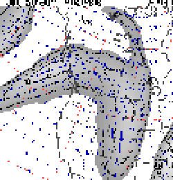
For actual satellite images of wind and cloud movement over hours or
days
click Prevailing Winds.
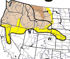
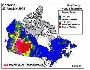
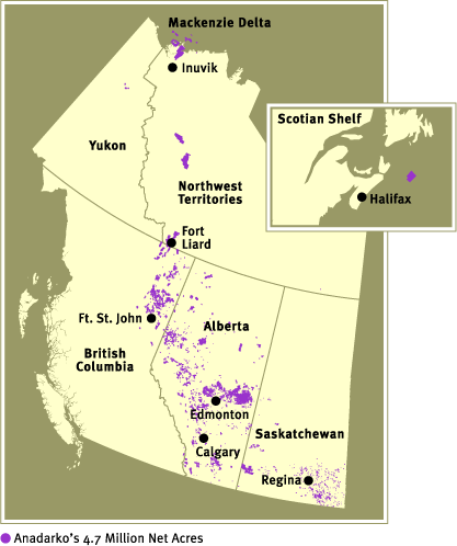
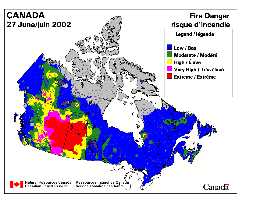
U.S. Drought Conditions February-March, 2001
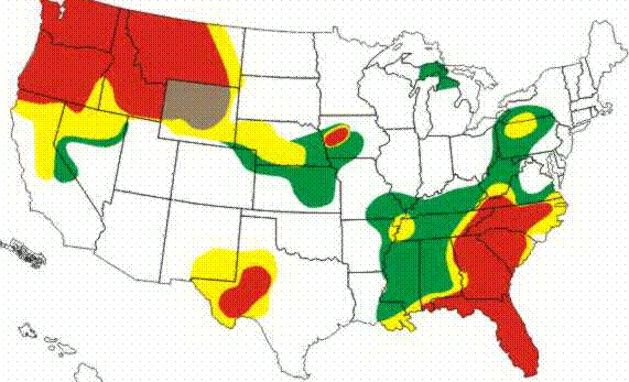
The
following is a comparison of Canadian petroleum fields and
fire danger in June, 2002. A difference between the above
drought picture and below is how the winds shift with the
seasons. In winter, winds carry the
dessicating plumes toward the US. In summer, the
winds carry the CO2 "salts"
easterly across Canada. In particular, in the
left map, note
the petroleum deposits upward toward the Mackenzie Delta
with corresponding fire danger coloration in the right map. (These
maps show the same near overlap of oil field plumes and
droughts/fires as is
found in central
Africa.)
Additional Information:
-
010706 "Feds consider
calling in federal marshals in water fight"
On Wednesday, about 100 people used a chain saw, their bare hands and
a cutting torch to open one of the six headgates holding back the waters
of Upper Klamath Lake. They complained that the waters were not reaching
their fields.
-
010708 "Western
Drought Victims War Over Water"
-
010814 "From Alberta, Energy's
Good Guy (and Bad Guy)"
-
020425 "Fire season
rages early in Colorado"
-
020501 "Canadian Oil Firms
Raise Objections To U.S. Tax Credits for Alaska Project"
Some U.S. analysts say American taxpayers will pay billions of dollars
more for natural gas under the Senate plan than they would without it.
-
020503 "Dry High Plains Are Blowing
Away, Again"
In eastern Montana, more than a thousand wheat farmers have called it
quits.
Here in southeastern Colorado, in the heart of the old Dust Bowl, the
ground is so dry that agriculture officials say most of this state will not
even produce a wheat crop.
According to the latest assessment by federal officials, half of Montana,
all of Wyoming, nearly two-thirds of Colorado, half of Kansas, a third of
Texas and most of New Mexico are in the midst of a drought labeled severe
to extreme. Wildfires are racing through the eastern front of Colorado. With
280 fires already this year, Colorado has had four times as many fires as
normal.
-
020519 "Incongruity in Wyoming:
Costly Energy Amid Bounty"
-
020600 Canadian Fires Image
-
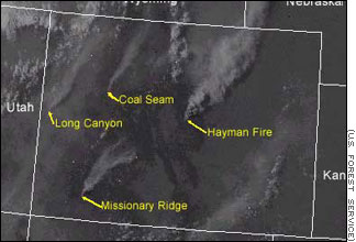
020612 Colorado Fires Image
-
020620 Colorado Fires Image
-
020802 "Canadian farmers
despair in Prairie drought"
"Sweltering under soaring temperatures and pestered by swarms of grasshoppers,
many farmers on Canada's Prairies are conceding defeat as acres of anxiety
rather than fields of grain thrive on their parched land."
-
020909 "Colorado
River not doing job"
"The drought-stricken Colorado River delivered barely one-eighth the amount
of water needed to supply Arizona, Nevada and California this year, leaving
the three states to draw heavily on water stored in Lakes Mead and Powell."
-
020909 "Golden
fights for water in court"
|